dynamic @FetchRequest with MapKit and SwiftUI
- Context
- Hello World
- Logging the Visible Map Region
- Plotting a Polyline
- Using Core Data
- Filtering results with NSPredicate
Context
I had an idea for an iOS app that would display my location history in a
visually interesting way and ran into this problem: How do I change the
@FetchRequest's predicate when someone pans or zooms the map? I was
able to setup the location tracking, storing coordinates with CoreData,
but once I started loading > ~100 data points and plotting them on the
map, the app became unusably laggy. I made the app a little less laggy
by selecting all of the location coordinates and conditionally placing
them on the map, but I knew this would eventually become a problem. It
reminded me of the difference between these two Ruby on Rails
implementations:
# bad, because it selects every post and filters in the application server
@posts = Post.all.select{ |post| post.user_id == 1 }

# good, because it delegates the filtering to the database
@posts = Post.where(user_id: 1)
There are several answers to "How do I dynamically set the predicate for
a @FetchRequest", but all of the answers I could find relied on the
view making the request to adhere to the View protocol, and not the
MapContent protocol.
In this post, I'll walk through how to dynamically set the @FetchRequest
predicate when the map is moved.
I am using Xcode 15.4 and Swift 5.
Hello World
Create a new project in Xcode. Select SwiftUI as the interface and
Core Data as the storage values.
I deleted everything inside of ContentView.swift, imported MapKit
and added Map to the view, ending up with this:
import SwiftUI
import CoreData
import MapKit

struct ContentView: View {
    var body: some View {
        Map()
    }
}
Logging the Visible Map Region
The onMapCameraChange method is invoked as the user zooms or
pans the map.
 struct ContentView: View {
     var body: some View {
-        Map()
+        Map().onMapCameraChange(frequency: .continuous) { context in
+            print(context.region)
+        }
     }
 }
Run and build the project, and then move the map. You'll see a bunch of logs that look like this:
MKCoordinateRegion(
    center: __C.CLLocationCoordinate2D(
        latitude: 37.75623306438235,
        longitude: -97.1149625444021
    ),
    span: __C.MKCoordinateSpan(
        latitudeDelta: 97.2521631165165,
        longitudeDelta: 68.75137004868748
    )
)
So far so good, but I needed to know the bounds of the region so that
eventually I can set upper and lower limits for the latitude and
longitude in the @FetchRequest.
A small helper method should do the trick:
struct Bounds {
    var minLatitude: Double
    var maxLatitude: Double
    var minLongitude: Double
    var maxLongitude: Double
}

func bounds(region: MKCoordinateRegion) -> Bounds {
    return Bounds(
        minLatitude: region.center.latitude - (region.span.latitudeDelta / 2.0),
        maxLatitude: region.center.latitude + (region.span.latitudeDelta / 2.0),
        minLongitude: region.center.longitude - (region.span.longitudeDelta / 2.0),
        maxLongitude: region.center.longitude + (region.span.longitudeDelta / 2.0)
    )
}
and
-            print(context.region.)
+            print(bounds(region: context.region))
I did a quick check by moving the map towards known values (the equator's latitude is zero, any latitude above is positive, and any latitude below is negative).
Plotting a Polyline
 struct ContentView: View {
     var body: some View {
-        Map().onMapCameraChange(frequency: .continuous) { context in
+        Map(){
+            MapPolyline(coordinates: [
+                // Montreal
+                CLLocationCoordinate2D(latitude: 45.5019, longitude: -73.5674),
+                // Austin
+                CLLocationCoordinate2D(latitude: 30.2672, longitude: -97.7431),
+                // Seattle
+                CLLocationCoordinate2D(latitude: 47.6061, longitude: -122.3328),
+            ]).stroke(.blue, lineWidth: 2.0)
+        }.onMapCameraChange(frequency: .continuous) { context in
             print(bounds(region: context.region))
         }
     }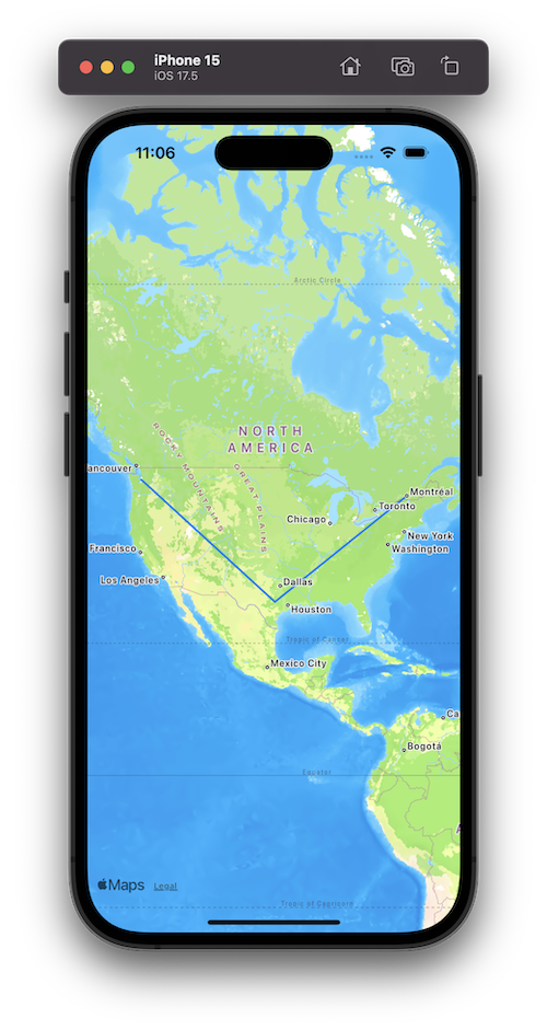
I chose to draw a polyline on the map so that when one of the points is out of the map's view, the line will (eventually) not extend out beyond the visible map. See how Montreal is currently out of the view, but the point is still in the polyline?
We'll soon fix this, but need to retrieve the points using Core Data first.
Using Core Data
The original Xcode generated project had the FetchRequest property
wrapper on the main ContentView:
struct ContentView: View {
    @Environment(\.managedObjectContext) private var viewContext

    @FetchRequest(
        sortDescriptors: [NSSortDescriptor(keyPath: \Item.timestamp, ascending: true)],
        animation: .default)
    private var items: FetchedResults<Item>
Because the map's movement should determine the predicate, we have to
fetch the results on a subview that can be embedded within Map(){...}.
Let's move the existing PolyLine to its own view:
struct PolylineView: MapContent {
    var body: some MapContent {
        MapPolyline(coordinates: [
            // Montreal
            CLLocationCoordinate2D(latitude: 45.5019, longitude: -73.5674),
            // Austin
            CLLocationCoordinate2D(latitude: 30.2672, longitude: -97.7431),
            // Seattle
            CLLocationCoordinate2D(latitude: 47.6061, longitude: -122.3328),
        ]).stroke(.blue, lineWidth: 2.0)
    }
}
and
 struct ContentView: View {
     var body: some View {
         Map(){
-            MapPolyline(coordinates: [
-                // Montreal
-                CLLocationCoordinate2D(latitude: 45.5019, longitude: -73.5674),
-                // Austin
-                CLLocationCoordinate2D(latitude: 30.2672, longitude: -97.7431),
-                // Seattle
-                CLLocationCoordinate2D(latitude: 47.6061, longitude: -122.3328),
-            ]).stroke(.blue, lineWidth: 2.0)
+            PolylineView()
         }.onMapCameraChange(frequency: .continuous) { context in
             print(bounds(region: context.region))
         }
How do I get those coordinates into Core Data? In my own app, I am
inserting coordinates in the background using CLLocationManager, but I
wanted to include something useful for this demo.
I am much more familiar with SQL than I am swift, so I selected
Product > Scheme > Edit Scheme... and added the two following
options under the "Arguments Passed on Launch" section:
-com.apple.CoreData.SQLDebug 1
-com.apple.CoreData.Logging.stderr 1
Re-building the app now shows me where the sqlite file is on disk in the logs:
CoreData: annotation: Connecting to sqlite database file at "/Users/jesse/Library/Developer/CoreSimulator/Devices/CFF7FA30-3B35-464A-96D1-20FC28675F23/data/Containers/Data/Application/5AF02136-1634-4479-8C3A-32B7A654A27D/Library/Application Support/dynamic_map_fetch_request.sqlite"
and now I can open a sqlite prompt:
$ sqlite3 "/Users/jesse/Library/Developer/CoreSimulator/Devices/CFF7FA30-3B35-464A-96D1-20FC28675F23/data/Containers/Data/Application/5AF02136-1634-4479-8C3A-32B7A654A27D/Library/Application Support/dynamic_map_fetch_request.sqlite"

SQLite version 3.43.2 2023-10-10 13:08:14
Enter ".help" for usage hints.
sqlite>
Delete everything:
sqlite> DELETE FROM ZITEM;
And add our coordinates:
INSERT INTO ZITEM (ZLATITUDE, ZLONGITUDE)
VALUES
(45.5019, -73.5674),
(30.2672, -97.7431),
(47.6061, -122.3328);
Nice! Now let's modify the PolylineView to retrieve those coordinates
from Core Data.
struct PolylineView: MapContent {
    @FetchRequest var fetchRequest: FetchedResults<Item>

    init(){
        _fetchRequest = FetchRequest<Item>(sortDescriptors: [])
    }

    var body: some MapContent {
        let coordinates = fetchRequest.map { item in
            CLLocationCoordinate2D(
                latitude: item.latitude,
                longitude: item.longitude
            )
        }
        MapPolyline(coordinates: coordinates).stroke(.blue, lineWidth: 2.0)
    }
}
Filtering results with NSPredicate
Just to make sure we can filter items, add an NSPredicate to the
FetchRequest and make sure only two points appear for the polyline:
     init(){
-        _fetchRequest = FetchRequest<Item>(sortDescriptors: [])
+        _fetchRequest = FetchRequest<Item>(
+            sortDescriptors: [],
+            predicate: NSPredicate(
+                format: "latitude > %f",
+                40.0
+            )
+        )
     }
Nice! The last part of this functionality is passing the region into
the PolylineView when the map moves, and updating the NSPredicate
to filter based on the min and max latitude and longitude values.
Pass the region into the polyline view:
+    @State var region: MKCoordinateRegion?;
     var body: some View {
         Map(){
-            PolylineView()
+            PolylineView(region: region)
         }.onMapCameraChange(frequency: .continuous) { context in
-            print(bounds(region: context.region))
+            region = context.region
         }
     }
 }
and modify the constructor to take a region argument:
init(region: MKCoordinateRegion?){
if region != nil {
let regionBounds = bounds(region: region!)
_fetchRequest = FetchRequest<Item>(
sortDescriptors: [],
predicate: NSPredicate(
format: "latitude > %f AND latitude < %f AND longitude > %f AND longitude < %f",
regionBounds.minLatitude,
regionBounds.maxLatitude,
regionBounds.minLongitude,
regionBounds.maxLongitude
)
)
} else {
// fetch nothing (the region is not yet defined)
_fetchRequest = FetchRequest<Item>(
sortDescriptors: [],
predicate: NSPredicate(
format: "latitude = %f",
-200.0
)
)
}
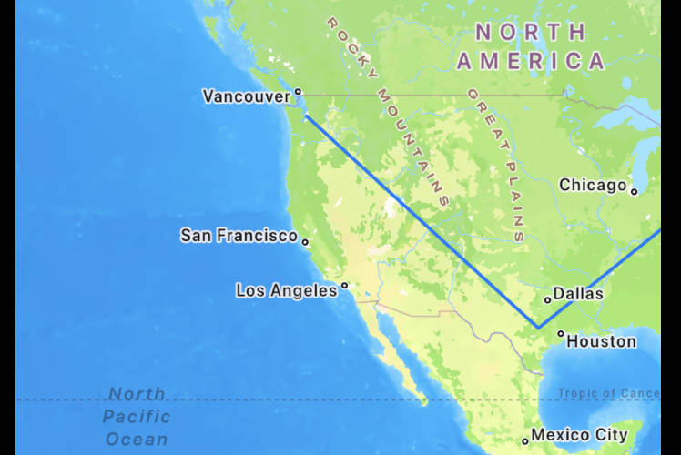
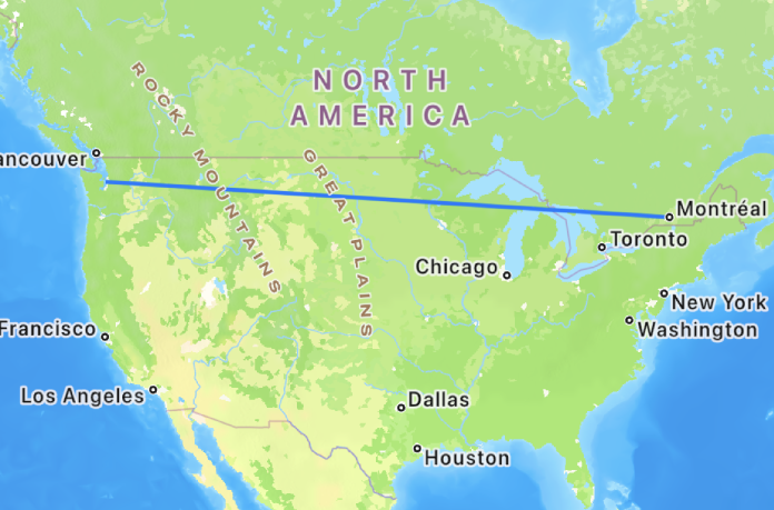
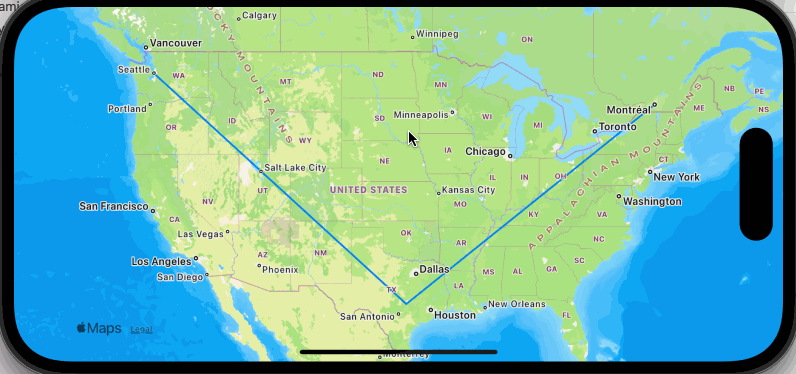
}And now when I move the map, only coordinates that are within the map's visible are are selected:
Here is the entire ContentView.swift:
import SwiftUI
import CoreData
import MapKit

struct PolylineView: MapContent {
    @FetchRequest var fetchRequest: FetchedResults<Item>

    init(region: MKCoordinateRegion?){
        if region != nil {
            let regionBounds = bounds(region: region!)
            _fetchRequest = FetchRequest<Item>(
                sortDescriptors: [],
                predicate: NSPredicate(
                    format: "latitude > %f AND latitude < %f AND longitude > %f AND longitude < %f",
                    regionBounds.minLatitude,
                    regionBounds.maxLatitude,
                    regionBounds.minLongitude,
                    regionBounds.maxLongitude
                )
            )
        } else {
            // fetch nothing
            _fetchRequest = FetchRequest<Item>(
                sortDescriptors: [],
                predicate: NSPredicate(
                    format: "latitude = %f",
                    -200.0
                )
            )
        }
    }

    var body: some MapContent {
        let coordinates = fetchRequest.map { item in
                    CLLocationCoordinate2D(latitude: item.latitude, longitude: item.longitude)
        }
        MapPolyline(coordinates: coordinates).stroke(.blue, lineWidth: 2.0)
    }
}

struct ContentView: View {
    @State var region: MKCoordinateRegion?;
    var body: some View {
        Map(){
            PolylineView(region: region)
        }.onMapCameraChange(frequency: .continuous) { context in
            region = context.region
        }
    }
}

struct Bounds {
    var minLatitude: Double
    var maxLatitude: Double
    var minLongitude: Double
    var maxLongitude: Double
}

func bounds(region: MKCoordinateRegion) -> Bounds {
    return Bounds(
        minLatitude: region.center.latitude - (region.span.latitudeDelta / 2.0),
        maxLatitude: region.center.latitude + (region.span.latitudeDelta / 2.0),
        minLongitude: region.center.longitude - (region.span.longitudeDelta / 2.0),
        maxLongitude: region.center.longitude + (region.span.longitudeDelta / 2.0)
    )
}